Financial District and Seaport Climate Resilience Master Plan
 Image credit: NYCEDC, NYCMOCR, ARCADIS
After reading this NY1 article on proposed or in-progress resilience projects in NYC, I skimmed the new “Financial District and Seaport Climate Resilience Master Plan” which was released in late December 2021. The report and accompanying project is one of many discrete resilience/adaptation projects in the works to protect lower Manhattan, New York’s “inner borough.” The project area stretches one mile from the Battery to the Brooklyn Bridge on Manhattan’s southest tip. The Master Plan was prepared by the NYC Mayor’s Office of Climate Resiliency, the NYC Economic Development Corporation, and ARCADIS.
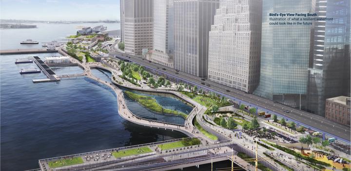
As part of the proposed design, the city’s report concludes the project would require “extending the shoreline of Lower Manhattan into the East River to create the space necessary to build flood defense infrastructure.” As opposed to the oft-cited and increasingly-employed strategy of “managed retreat,” this statement suggests the city will instead entrench, fortify, and even advance in the face of rising seas and more intense storms. The flood defense infrastructure included in the plan proposes construction of buried floodwalls, as well as floodgates which would be used only periodically during more extreme surge events. The buried floodwalls would require “permenantly raising the height of the shoreline,” in order to protect against rising sea levels. This would transform the one-mile portion of Manhattan’s shoreline. Renderings— one of which is shown above— indicate a vision for walkable design that might meet the community’s competing needs of flood protection and accessible green space.
The report notes the area of Manhattan south of Canal Street has experienced a 170% increase in residents since 2000! Population growth in the floodplain is by no means unique to lower Manhattan, but this trend provides further motivation to protect this part of the city, which has historically been a critical financial, transportation, and tourism hub and is now also a growing residential community.
This one-mile plan is a long way from breaking ground, let alone providing meaningful flood protection to lower Manhattan. The report states the Master Plan will “likely take 15 to 20 years to fully implement,” and my guess it will be closer to 20 than 15. The estimated price tag is $5-7 billion dollars, and in the event it moves forward, funding will likely come from a patchwork of city, state, and federal sources. In addition to the time-consuming and complex permitting process the project will need to overcome, recent tensions around the East Side Coastal Resiliency Project portend the potentiall for heated land use battles over this large-scale flood protection project that would disrupt scarce green space in one of the country’s densest and wealthiest areas.
Despite meaningful land use concerns, the need for strengthened flood protection is very real (assuming people continue building and moving into the area). The IPCC’s Sixth Assessment Report concludes with high confidence that annual global mean sea level rise has nearly tripled since the early 20th century and continues to accelerate. There is also high confidence sea levels are already committed to rise for centuries (perhaps millennia) into the future. The fact that sea levels will continue rising in our lifetimes is certain; what is still uncertain, however, is the rate at which they rise and how society responds. The illustration below shows what one area underneath the FDR Drive might look like in the future without adaptation at certain levels of inundation. Building this massive flood protection system would be disruptive and costly, however doing nothing would be a different version of disruptive and costly. There are also residents in outer boroughs who face similar flooding possibilities without prospect for multibillion-dollar infrastructure investments. I’ve spoken to some who would jump at the chance for well-designed, comprehensive flood protection investment in their neighborhoods.
